Patras - Earthquake: Danger from the Psathopyrgos fault and craters that "steam" in the port

EARTHQUAKES IN PATRAS AND CRATERS IN THE NEW PORT
In addition to the 2008 earthquake, which Patras felt strongly, on July 14, 1993 a strong earthquake, measuring 5.5 on the Richter scale, caused considerable damage to the city and its suburbs.
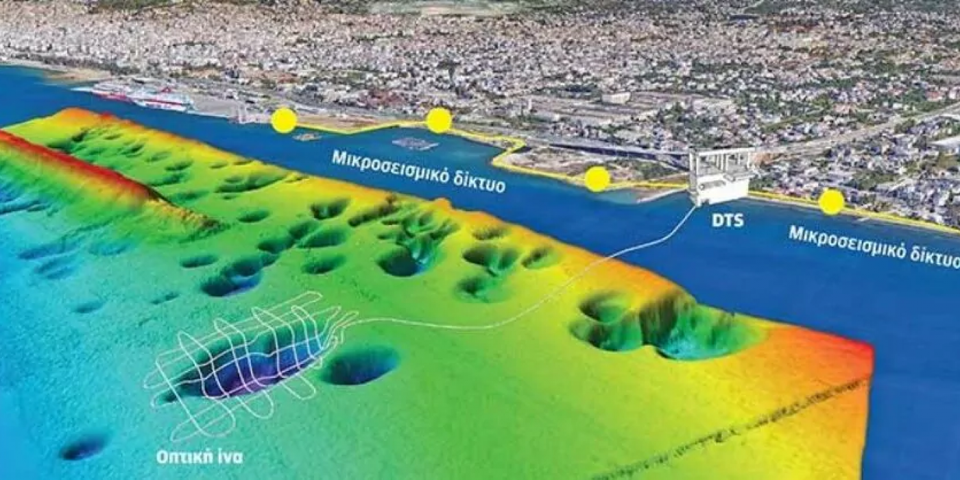
A field of underwater craters was discovered in the area of the new port of Patras, just a few hundred meters from the coast, which during the earthquake "steamed", releasing large quantities of gases. This field is the subject of a new research program by the University of Patras, which, using new technologies, examines whether the release of gases from the craters can be considered a precursor to an earthquake, but also the consequences of this escape on the greenhouse effect.
George Papatheodorou, professor at the Department of Geology at the University of Patras, is responsible for the research.
Before the construction of the new port of Patras, the field numbered 72 craters, the largest of which has a diameter of 200 meters and a depth, in relation to the bottom, of 20 meters.
In the 1993 Patras earthquake, the field activity was recorded by instrumentation hours before the earthquake, suggesting the scenario that possibly the gas escapes appeared as precursor phenomena, a few hours before the occurrence of the earthquake. Extensive activity of the field, with large gas leaks, was also found in the earthquake of Ilia - Western Achaia on June 8, 2008 (6.4 R)!
THE WEST CORINTHIAN GULF
The area from Aegio to Antirrio is characterized by very intense seismicity and microseismicity. And who doesn't remember the "swarms" of earthquakes in the Rio area, in September 2020 when we "felt" that the earth was constantly shaking under our feet, while in Rio, the residents were terrified by constantly hearing "rumblings"! The western Corinthian "opens" by 1.5 cm per year, while many small and large faults run through it. These days, the western Corinthian Gulf is "quiet". Few earthquakes are observed and most of them with an intensity of 2.5 to 4 Richter.
At the beginning of 2021, several micro-earthquakes occurred again in this section, in an area from Epitalio to Trizonia. The largest and most dangerous of the faults in the area is that of Psathopyrgos, which is estimated to be longer than 20 km and can produce strong earthquakes, but it is not active right now. What can be done in the future, is of course unknown.
Article on Web
Latest Posts

Alarming pollution levels found in Mediterranean depths

"Why are the Posidonia meadows so valuable for our seas?": Article in LIFO
