Kyllene Harbour Project

Project: Ancient Harbour of Kyllini, Glarentza, Patras Gulf
Funded by the Finnish Institute of Athens
The Kyllene Harbour Project was a joint project of the Finnish Archaeological Institute at Athens and the Department of Underwater Antiquities (Ministry of Culture). It was conducted in collaboration with the Departament of History, Archaeology and Cultural Resources Management, University of the Peloponnese, and Oceanus-Lab (Laboratory of Marine Geology and Physical Oceanography, Department of Geology, University of Patras).
History
In classical antiquity Kyllene was the principal outport of ancient Elis, so a large part of the participants and spectators arriving to the Olympian games by sea would have landed there. Thucydides (2.86.1, 3.69.1–2) reports that during the Peloponnesian War (431–404 BCE) it was the major Spartan naval base against the Athenian naval forces in western Greece. In the Hellenistic period, the harbour remained of key strategic importance for the war fleets of the Ptolemies and the Macedonians. The medieval fortifications and harbour installations are in many places built of re-used ancient blocks and Hellenistic and Roman pottery and coins have been documented in medieval strata.
|
At the end of the Fourth Crusade, after the fall of Constantinople, western Peloponnese (Morea) was conquered in 1205 CE by the Franks who held it for more than two centuries as the Principality of Achaia. The Villehardouins developed the coastal city of Kyllene (then known as Glarenza) as a significant strategic post and they also fortified the settlement. Due to its ideal location between mainland Greece and Italy, the city-harbour emerged rapidly as one of the most famous international centres of medieval Europe: ships from Venice and Genoa transited goods from all of Frankish Greece to Western Europe. The harbour flourished for two centuries, but in the early fifteenth century its fortunes were reversed: between 1407 and 1428 it changed hands five times and in 1431 the Byzantine Konstantinos Palaiologos destroyed its walls to prevent a new capture of the city and the harbour. The remains of harbour installations of the medieval port are very extensive, including an inner and an outer harbour, demonstrating that the flourishing Crusaders’ port consisted of different sections. One of the principal purposes of the interdisciplinary study is a detailed survey of the submerged remains in order to comprehend the layout of the harbour and to reconstruct the coastline for the different construction phases of the port (Classical and Medieval).
|
 |
Study area
The coastal area under study is located at the northern end of the promontory of the Chlemoutsi headland, at the northwestern coast of the Peloponnese. Geologically, the area is a segment of a large coastal sandy plain with barrier lagoons, the Elis coastal plain, extending along the western coast of the Peloponnese. The coastal formations consist of Holocene alluvial deposits made up of colluvium, fluvio-torrential sediments, coastal dunes and beach material. At present, the shoreline of the Elis coastal plain is controlled by transgression and erosion, but in the past the coastal evolution had been controlled by the eustatic sea-level signal, local tectonic instability and diapirism.
Archaeological survey
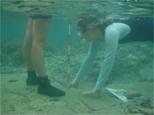
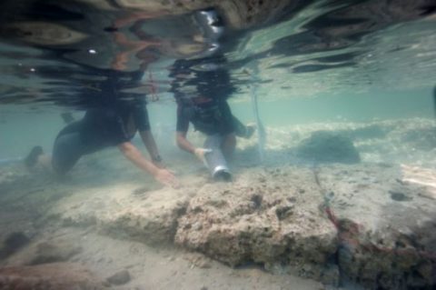
The archaeological survey concentrated on the precise 3D topographical investigation using total stations to measure details of the harbour remains and shallow-water features.
Marine geophysical survey
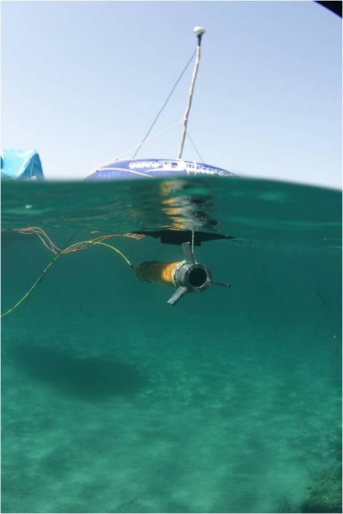
The marine geophysical study which was performed by Oceanus-Lab employed a 3.5 kHz subbottom profiler system in order to examine the seafloor bathymetry and the recent subbottom stratigraphy of the coastal area. A side scan sonar system was employed in order to examine the seafloor surface composition and the existence of potential targets on the seafloor. Furthermore, an Overhauser magnetometer survey was conducted in order to investigate the magnetic signature of the seafloor, especially in the area where the harbour remains are concentrated. Magnetometer has been successfully employed at Caesarea Maritima in Israel, but as far as we were aware it was the first time it was employed for harbour studies in Greece.
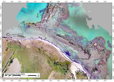
The aim of the research was to study the geomorphological features of the ancient and medieval harbour by using non-destructive remote sensing methods. In the field campaigns of 2007-2009, the marine geophysical instrumentation carried out a dense grid of parallel and vertical lines to the shoreline, whilst the topographic survey of the underwater remains recorded more than 30,000 points which give detailed picture of the archaeological remains and their current setting. The water depths recorded by the echosounder and the shallow-water topographical survey were combined to present the total bathymetry of the area. All the collected data were georeferenced and displayed in a G.I.S. environment.
The synthesis of the collected data revealed the aerial distribution of the submerged harbour remains and the seafloor morphology related to the different ancient port installations. Furthermore, it revealed targets of potential archaeological interest. Finally, the study demonstrated that the use of remote sensing techniques in conjunction with detailed archaeological and topographical survey in shallow-water coastal sites could be an effective methodological approach for the study of submerged ancient ports and coastal installations in the eastern Mediterranean.
Results
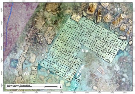
In 2007–2017, the Kyllene Harbour Project has studied in detail all the outer harbour structures which are currently underwater. The inner harbour is on dry land and outside the research area of the project. The three-dimensional model of the harbour structures in the background of the image was created from aerial photos. The deepest points of the model at the north end of the breakwater S6 are c. 6 m below the surface of the sea. The resulting model matches very well with the stone-by-stone total station survey of the study area. The readability of the plan is greatly enhanced by superimposing the total station line-drawing on top of it. The medieval harbour entrance from the north-east between S1 and S2 is clear and it is very likely that the mouth was blocked by destroying the towers on the both sides of the entrance. This also matches the literary descriptions of the destruction of the installations in 1431.
The research project has verified that there are ancient harbour structures below the medieval Frankish ones. W1 is a typical Frankish fortification wall built in mixed technique employing reused ashlar blocks and rubble set in mortar. Structure S1a is what remains of a Greek tower built of ashlar blocks and protected from the waves by the Frankish structure S1b partially built on top of it. S1a is a clear indication of the rise in relative sea levels from antiquity to present day: the top surface is currently 0.6m below the sea level. The data collected in the maritime geomorphological study has revealed the spatial distribution of the submerged harbour remains and the seafloor morphology related to the different port installations. Finally, the study has demonstrated that the use of remote sensing techniques in conjunction with detailed archaeological and topographical survey in shallow-water coastal sites could be an effective methodological approach for the study of submerged ancient ports and coastal installations in the eastern Mediterranean.
Sources: