Caska Bay Project, Croatia

Funding:
|
|
|
Aix-Marseille Université |


The remote sensing survey which was carried out in Caska Bay, located in the northern part of the Pag Island, Croatia. Oceanus-Lab (Laboratory of Marine Geology and Physical Oceanography of the Department of Geology, University of Patras, Greece) was invited to participate in the 2012 excavation campaign of the Caska Project by conducting a marine geophysical survey in Caska Bay. The survey was carried out from 17th to 24th May 2012, by Oceanus-Lab in cooperation with Zadar University and the CNRS.
The Caska Bay marine remote sensing survey is a research project designed: • to survey in detail an ancient shipwreck located at the northern end of Caska Βay, • to detect targets (surface and subsurface) of potential archaeological interest, • to obtain detailed bathymetry of Caska Bay and the approaching area of the bay, • to define the subbottom stratigraphy of the recent sediment sequence, • to define the evolution of the coastline configuration around Caska Bay and the surrounding area over the last 18,000 yrs BP based on seismic stratigraphhy and the mapping of palaeoshorelines.
Modern underwater remote sensing technology introduces many advantages that extend the range of conventional diving work providing the means to survey in a detailed and systematic fashion large seafloor area. The advantages of such surveys are: (i) high speed of investigation the seafloor which is time consuming and therefore can be also proven cost-effective; (ii) ability to detect buried targets; (iii) ability to detect obscure geometrical shapes on the macroscopic scale due to the broader available seabed view than that of the visual field of a diver; (iv) less environmental constrains such as for carrying out the survey (low visibility, dirty and polluted waters, strong currents); (v) precision of seafloor mapping; (vi) higher than visual resolution and (vii) reduced diving hours and unnecessary risks. The underwater remote sensing techniques most commonly applied to underwater archaeology employ: (i) single and multi-beam echosounders; (ii) side scan sonar (acoustic imaging); (iii) laser line scan (optical imaging); (iv) subbottom profiler; (v) marine magnetometer and (vi) undersea vehicles.
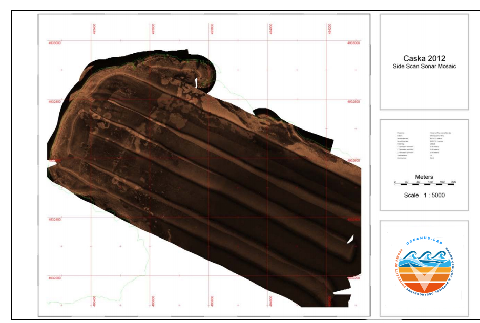
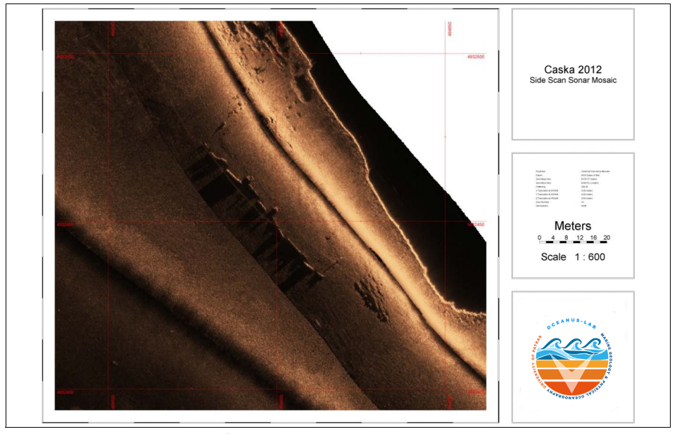
Field activities in Caska Bay as well as the surrounding during May 2012 survey period included: • the detailed bathymetry of the ancient harbours and their approaching area; • the morphology of the seafloor; • the study of the seabed seismic stratigraphy. Emphasis was placed on determining targets of potential archaeological interest and the submerged palaeoshorelines. The marine remote sensing survey was carried out using a 3.5 kHz Geopulse subbottom profiler, a single-beam echosounder and an EG&G side scan sonar. A Hemisphere V100 GPS system with accuracy of approximately 1.5 m was used for the navigation and the positioning. The side scan sonar survey in the very shallow waters of Caska Bay an over the ancient shipwreck was carried out using a small wooden boat, while the subbottom profiler, side scan sonar and echosounder surveys in the Caska bay were carried out using the vessel Nyroca III. Both vessels were suitably modified to meet the specific needs for the remote sensing survey.
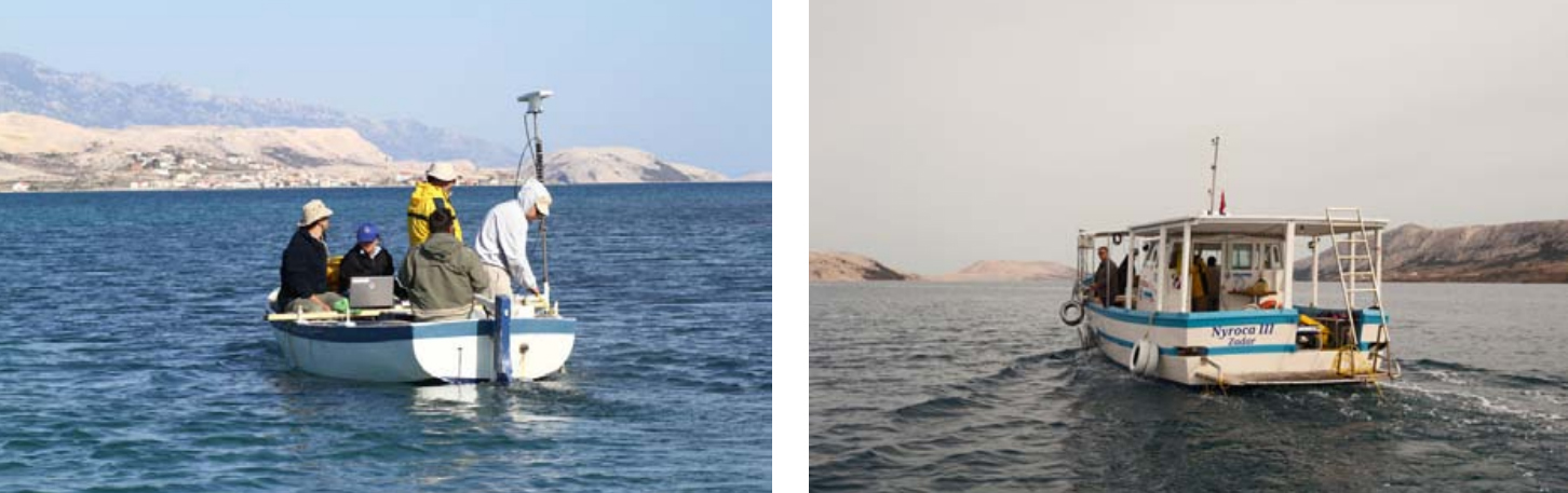
The small wooden vessel used for the surveying of the areas of shallow waters (on the right side of the boat see the Hemishpere V100 GPS system used for the positioning of the survey) and the m/b Nyroca III used for deeper waters, on the right (photos: left, S. Govorčin, Université de Zadar; right, Ph. Groscaux, CCJ/CNRS).
Side scan sonar survey
The side scan sonar survey aimed at the mapping of the geomorphological and textural features of the seafloor and the detection and positioning of targets which may represent manmade features. The side scan sonar system emits acoustic pulses providing a plan view seafloor acoustic image. The main advantage of a side scan sonar system is the ability to survey wide seafloor areas at a greater “over the ground” speed. The side scan sonar system consists of: • A dual frequency (100 and 500 kHz) towfish 272TD; • kevlar cables 50, 150 and 200 m; • digital recording unit Edgetech 4100P topside.
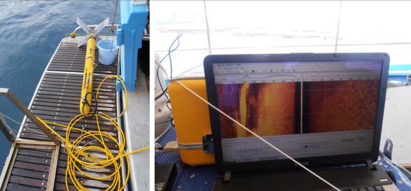
Dual frequency towfish 272TD with the Kevlar-type cable (left) and the digital recording unit Edgetech 4100P topside (right).
Over 100 side scan sonar lines having a total length of 121 km and covering whole Caksa Βay and the approaching area were surveyed. The side scan sonar lines were running: (i) parallel to shoreline of the bay, and (ii) perpendicular to the shoreline and the elongated axis of the bay. The side scan sonar survey at the very shallow waters and over the ancient shipwreck was carried out with range of 50 m and 25 m each side with the 500 kHz frequency, in order to achieve the best resolution of the side scan sonar system. The side scan sonar survey in the rest part of the bay was carried out with range of 150 m each side with the 100 kHz frequency. The line spacing was such that the seafloor area covered between two lines was overlapped by 50 %. The towfish was towed above the seafloor at a height ranging between 10 and 30 % of the lane range. The excellent quality of the acquired side scan sonar raw data will provide important information regarding the morphology of the seafloor ant the man-made targets lying on the seafloor.
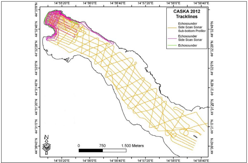
Map of the survey area showing the side scan sonar, subbottom profiler and echosounder tracklines in the Caska bay (Oceanus-Lab).
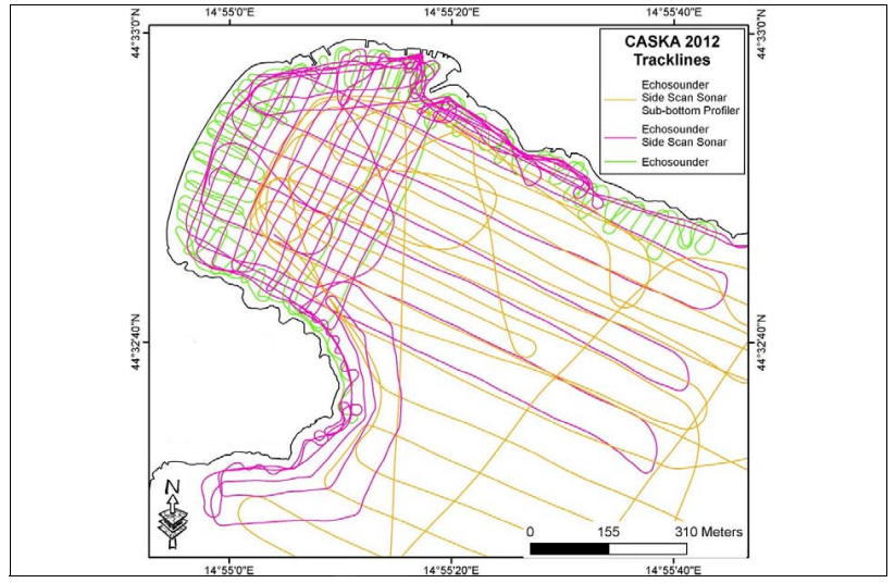
Map of the northern end of Caska bay showing instrumentation tracklines (Oceanus-Lab).
Subbottom profiling survey
The subbottom profiling survey at Caska Bay was carried out using a 3.5 kHz Geopulse subbottom profiler. The subbottom profiler system emits medium to high-frequency acoustic pulse in the form of acoustic conical beams providing a geological profile of the subbottom beneath the path over which the system is towed. A shallow-penetration, high-resolution subbottom profiling system permits the identification and mapping of submerged shorelines, which are now buried under loose marine sediments, seafloor morphological features indicative of submerged archaeological sites and buried targets of archaeological interest. The 3.5 kHz system consists of: • A Model 5430A GeoPulse Transmitter, • A Model 5210A GeoPulse Receiver, • A Triton Elics digital unit • An O.R.E. Model 132A/132B over-the-side Transducer Mounting.
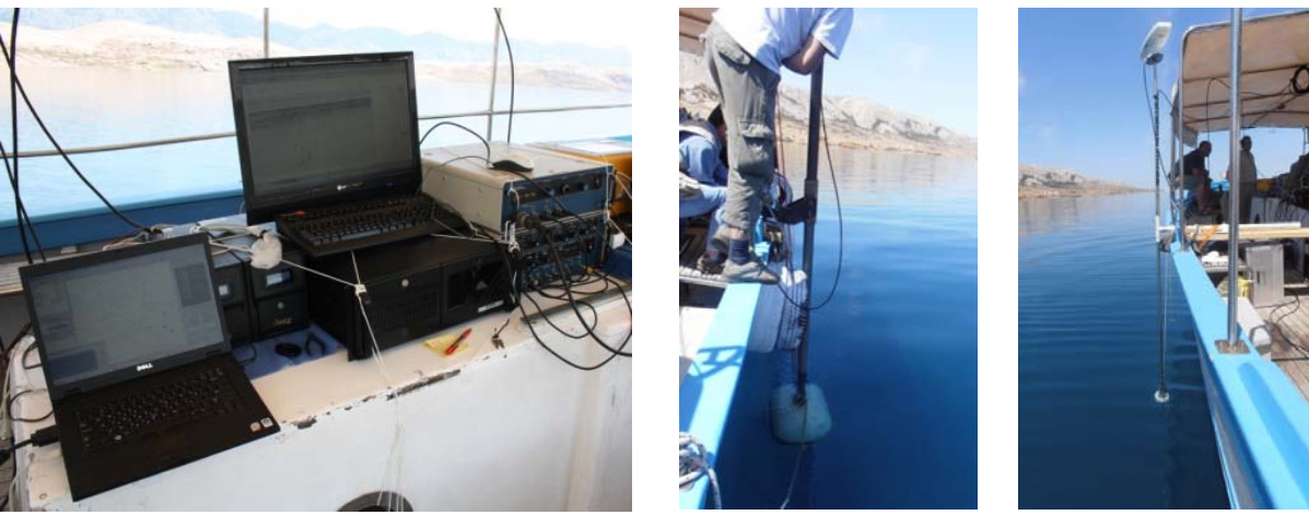
GeoPulse Transmitter, Receiver and the Triton Elics digital unit on the deck of vessel “Nyroca III” (left); O.R.E. Model 132A/132B over-the-side Transducer Mounting (centre) and the transducer of the bathymeter Elac Nautic Hydrostat 4300 together with the Hemisphere V100 GPS system (right).
Over 100 3.5 kHz subbottom profiler lines having a total length of 91 km were surveyed. For the detailed stratigraphy and for the reconstruction of the palaeogeography of Caska Bay the subbottom profiler lines were acquired perpendicular and parallel to the shoreline of the bay. A Time Base (T.B.) of 0.10 sec and a 0.1-msec pulse were used for the subbottom profiling survey in the area. The vertical resolution of the system was better than 0.3 m. The collected 3.5 kHz raw data is of excellent quality and allows the identification of the stratigraphy of the seafloor of the bay.
Bathymetric Survey
The bathymetric survey was carried out simultaneously with the subbottom profiling survey having a total length of tracklines about 133 km and using a digital singe-beam hydrographic echosounder Elac Nautic Hydrostat 4300 with accuracy of less than 5 cm in shallow water environments. The bathymetric survey was carried out in order to obtain detailed bathymetric data of the Caska bay in order to construct a detailed 53 bathymetric/geomorphological map. This map is crucial for the palaeogeographic reconstruction of the bay. 6.3. Geophisical data processing and preliminary results The bathymetric data will be processed using ArcGIS. For the processing of subbotom profiling data the SB-Interpreter (Triton Imaging Inc.) will be used. Two new softwares (SonarClass and TargAn) designed and proposed by the Laboratory of Marine Geology and Physical Oceanography will be used for the processing of the side scan sonar data. The TargAn toolbox has proved to be extremely helpful when large amounts of side scan sonar image targets need to be objectively clustered or classified and has been demonstrated through case studies of archaeological interest. For the side scan sonar mosaic, Isis and TritonMap (Trion Imaging Inc.) softwares will be used. A preliminary examination of the side scan sonar mosaics showed: (i) the existence of morphological features which are probably indicative of submerged palaeoshoreline and (ii) a number of acoustic anomalies (targets) of potential interest. Seismic 3.5 kHz profiles clearly show the seismic stratigraphy of Caska Βay. A preliminary investigation of the seismic profiles showed three sediment sequences which can be interpreted in terms of the palaeogeography of the bay.
Geophisical data processing and preliminary results
The bathymetric data will be processed using ArcGIS. For the processing of subbotom profiling data the SB-Interpreter (Triton Imaging Inc.) will be used. Two new softwares (SonarClass and TargAn) designed and proposed by the Laboratory of Marine Geology and Physical Oceanography will be used for the processing of the side scan sonar data. The TargAn toolbox has proved to be extremely helpful when large amounts of side scan sonar image targets need to be objectively clustered or classified and has been demonstrated through case studies of archaeological interest. For the side scan sonar mosaic, Isis and TritonMap (Trion Imaging Inc.) softwares will be used. A preliminary examination of the side scan sonar mosaics showed: (i) the existence of morphological features which are probably indicative of submerged palaeoshoreline and (ii) a number of acoustic anomalies (targets) of potential interest. Seismic 3.5 kHz profiles clearly show the seismic stratigraphy of Caska Bay. A preliminary investigation of the seismic profiles showed three sediment sequences which can be interpreted in terms of the palaeogeography of the bay.
Side scan sonar mosaic of the Caska cove (Oceanus-Lab).
Side scan sonar sonograph showing acoustic anomalies (targets) of potential interest (Oceanus-Lab).
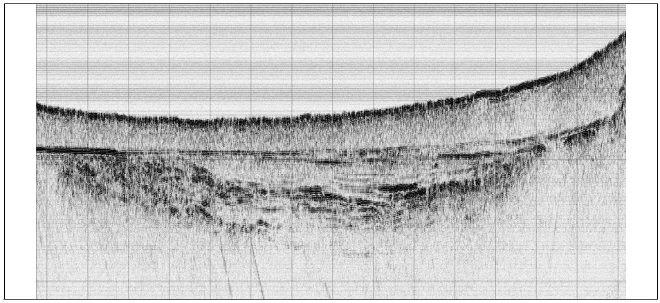
3.5 kHz seismic profile showing the stratigraphy of the Caska bay (Oceanus-Lab).